In the early 1800s, the High Falls, Georgia area had a prosperous industrial town with several stores, a grist mill, cotton gin, blacksmith shop, shoe factory, a geo-electric plant, and hotel. High Falls fell from prosperity in the 1880s when a major railroad bypassed it.
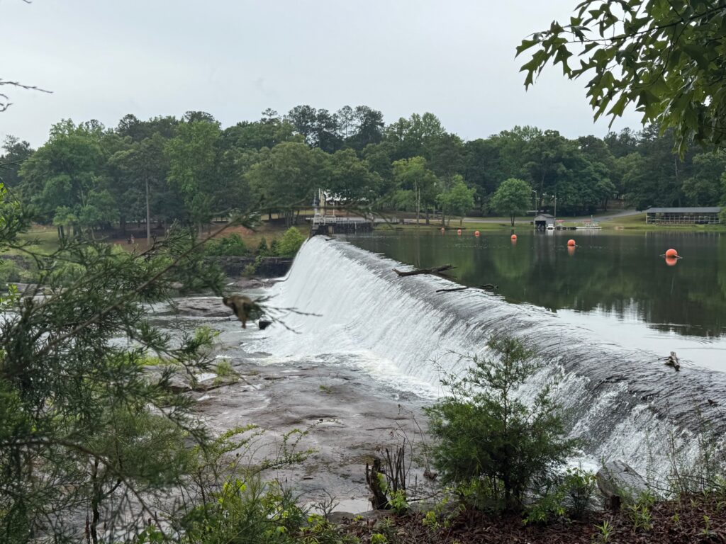
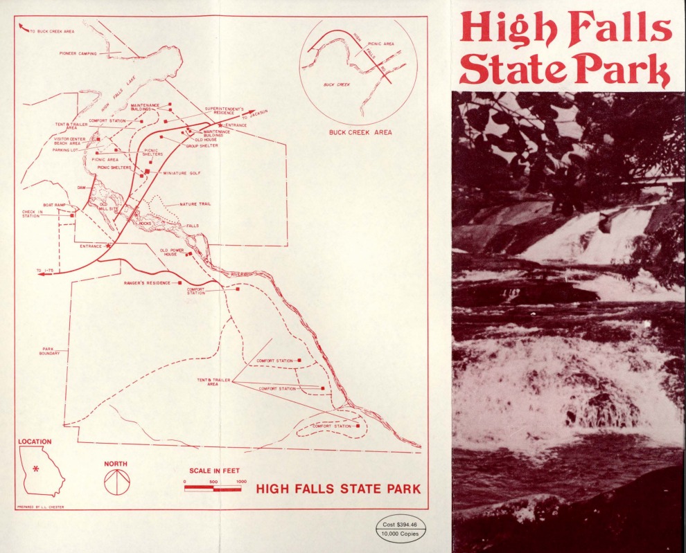
As the home to the highest waterfall south of Atlanta, High Falls has always been a popular destination for social gatherings, camping, fishing, swimming and picnics. In 1966, a state park (1,050 acres) was formed, encompassing the waterfall and the 650-acre High Falls Lake, leaving lots of room for trails. High Falls State Park is named for tumbling cascades on the Towaliga River.
This year High Falls State Park celebrates its 60th year. We reached out to our guest blog author and HFSP naturalist, Bronwen Morgan, for some history on the community and the park.
The History of High Falls, by Bronwen Morgan
The community of High Falls has lived and died by industry since the 1821 land lottery that created Monroe County. Waves of “capitalists,” as entrepreneurs were called in the 19th and early 20th centuries, arrived, built, and left town over the course of 150 years initially drawn by the power of the Towaliga River. Their hewn rocks and brick masonry stand crumbling under the weight of time. But the river remains. And this water is where the written record of High Falls begins.
We don’t know exactly how long people have been drawn to this river for its resources. But we do know the name “Towaliga” was given to it by the Native Americans now known as the Muscogee Creek Nation. The meaning of the word is uncertain. Local lore of a violent definition involving scalps can be traced to one dubious source cited in the 1975 publication Placenames of Georgia by Kentucky native, John Goff. I say dubious because I’ve read Goff’s report. He accurately describes the difficulty of defining a word that pre-dates its own alphabet. When you consider varied pronunciations by people forming a word foreign to their language, the mystery deepens. Even Goff admits the single source for the gruesome definition was possibly inaccurate. A search in a Muscogee Creek online dictionary aligns with one of the less sensational possibilities Goff posits: “place of sumac,” a native plant which still grows along its banks. I have contacted a linguist of the Muscogee Creek Nation in the hope of clearing the waters, but one thing remains inarguable: the Muscogee were here.
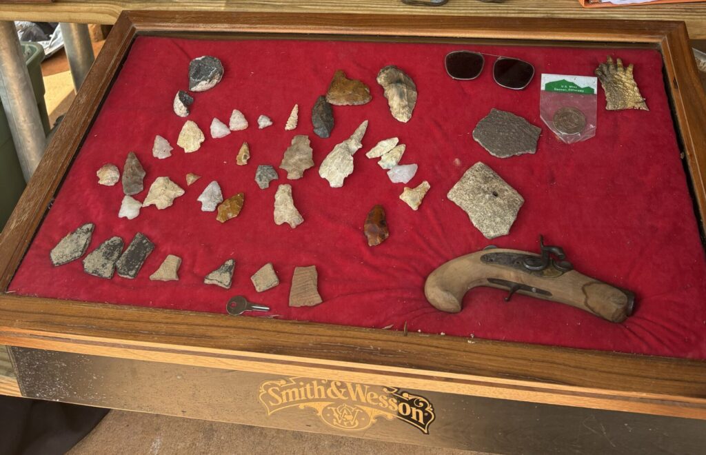
The land through which the Towaliga runs was a part of the First Treaty of Indian Springs in 1821, brokered by General William McIntosh (Tustunnuggee Hutke) of the Lower Towns. Locals, myself included, have found arrowheads in the river and its tributary creeks. The Old Alabama Road which once crossed the Towaliga River in High Falls by means of a ferry, followed by wooden bridges, and eventually a steel camelback bridge built in 1902 is said to be based on a Native American trade route. The Muscogee and their ancestors were probably here for time immeasurable before the Indian Removal act of 1830. Their language, Mvskoke, peppers our central Georgia landscape despite the eternal march of progress and industry that dominates our history.
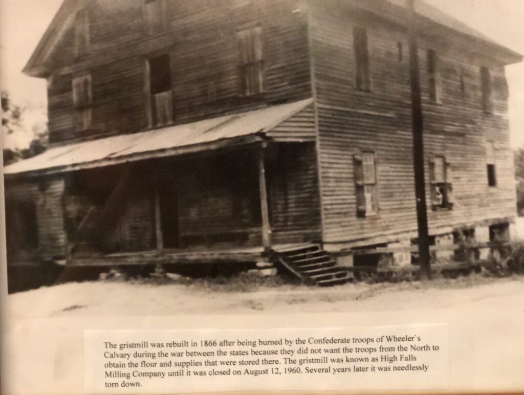
The earliest records of mills along the Towaliga River date to the early 1800s. An 1829 editorial from the Macon Telegraph paints a technicolor picture of what the water and land now encompassed by High Falls State Park looked like. At that time there were mills flanking the river. The remains of the foundation of the gristmill on the south bank still stand. This mill, believed to have been constructed in 1827 by a Mr. Waller and eventually belonging to Mr. T.S.M. Bloodworth, was intentionally burned by the Confederate troops of Commander Wheeler’s cavalry in November of 1864 as General Kilpatrick advanced his Union troops along Sherman’s March to the Sea at the end of the American Civil War. An article from the December 1893 edition of Sunny South magazine describes how militiamen burned the mill including “$2,000 worth of corn, wheat, meal and flour” as well as slaughtered 70 pigs, valued at $1,050, on the spot.
The mill was rebuilt after the war and operated until Georgia Power closed the powerplant in 1958, but in those later years of the 19th century the gristmill would not stand alone. It would be joined by other mills such as a saw mill and water powered cotton ginnery, as well as factories that produced furniture, brooms, shoes, farm implements, and other mass-produced items of the Industrial Revolution. People moved to the area to work, mostly for Mr. Bloodworth. High Falls became known far and wide for its annual May Day. People came from Atlanta and Macon and everywhere in between to recreate on Mr. Bloodworth’s property, much of which falls inside the park boundary today. The society page in the Monroe County Advertiser tracked the weekly movements of local prominent families much in the way social media does today. A Masonic lodge and high school shared a building until it was burned by suspected arson. Horse drawn buggies crossed the wooden bridge of the Old Alabama Road and sometimes didn’t make it safely to the other side. Bridges were destroyed by freshets and rebuilt mostly by Mr. Bloodworth. Commerce thrived along the Old Alabama road from Indian Springs and Jackson through High Falls into Griffin and beyond.
But as they say, nothing lasts forever and at some point in the late 1800s industry in High Falls came to a grinding halt. The accepted narrative seems to be that the area became a ghost town when the railroad bypassed High Falls for Jackson. The aforementioned Sunny South article, however, outlines a far less simplistic cause related to the Panic of 1873. This global economic crisis was the result of multiple related factors. Speculative investments in railroads created an economic bubble which burst as European investors sold off holdings due to financial instability primarily following the Vienna Stock Market Crash and the Franco-Prussian War. U.S. credit markets struggled as foreign capital dried up resulting in what came to be known as the Long Depression. Locally pains of this crisis were felt most acutely by High Falls’ greatest champion of the day, Mr. T.S.M. Bloodworth. The entrepreneur had co-signed a loan for a friend to the tune of $30,000 and when the panic hit, it seems Bloodworth was left holding the bag to the tune of $50,000 in principal and interest. The article lists changed economic conditions, advanced aged, and an ailing wife as all being too much for Mr. Bloodworth to rebuild as he had done after the Civil War. He shuttered his High Falls businesses to protect his credit, which essentially put the entire town out of work. Bloodworth left town, and as the Sunny South tells us, “With him departed the life of High Falls.”
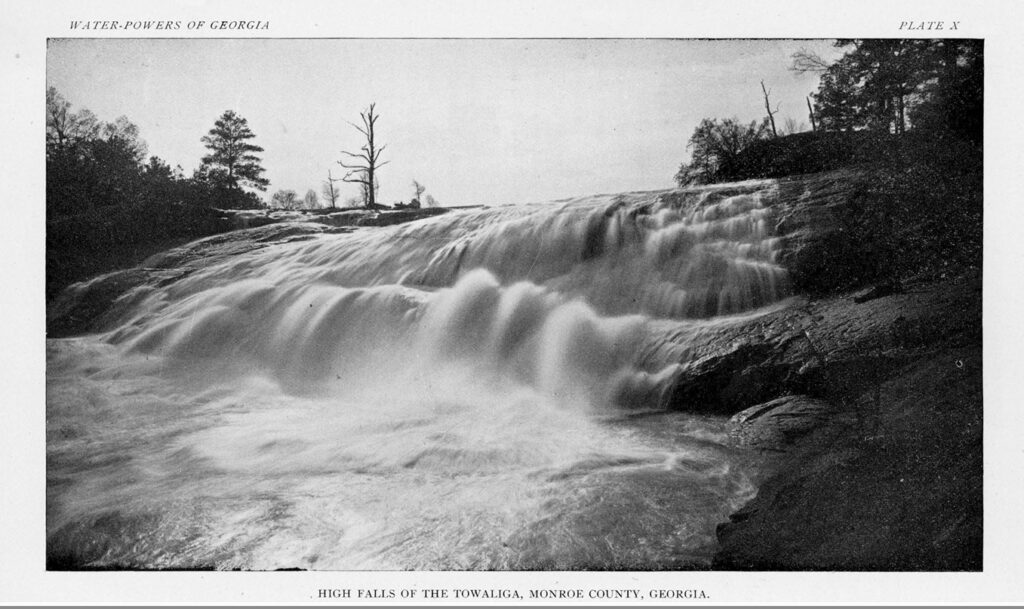
This village is not one that easily surrenders however, and if the river ran on, a resurrection was certain. High Falls indeed felt new life with the arrive of the electric age at the turn of the century. An 1896 geological survey titled “A preliminary report on a part of the water-powers of Georgia” assessed the untapped powers of Georgia’s rivers. It includes not only measurements of water flow and depth at the “High Falls of the Towaliga,” but also a stunning black and white photograph apparently taken from the same vantage point as one of the park’s existing viewing platforms today. Electrical advancements along Georgia’s waterways happened so fast the authors of the survey, State Geologist W.S. Yeates and Assistant B. M. Hall, did not have time to complete a scheduled follow up study. “Capitalist” Captain Seaton Grantland and his team of engineers, lawyers, and investors were on the banks of the Towaliga in High Falls by 1897 planning their hydroelectric dam system that promised to truly revolutionize the lives of everyone in the area. Much as today, the possibilities tied to new industry seemed endless.
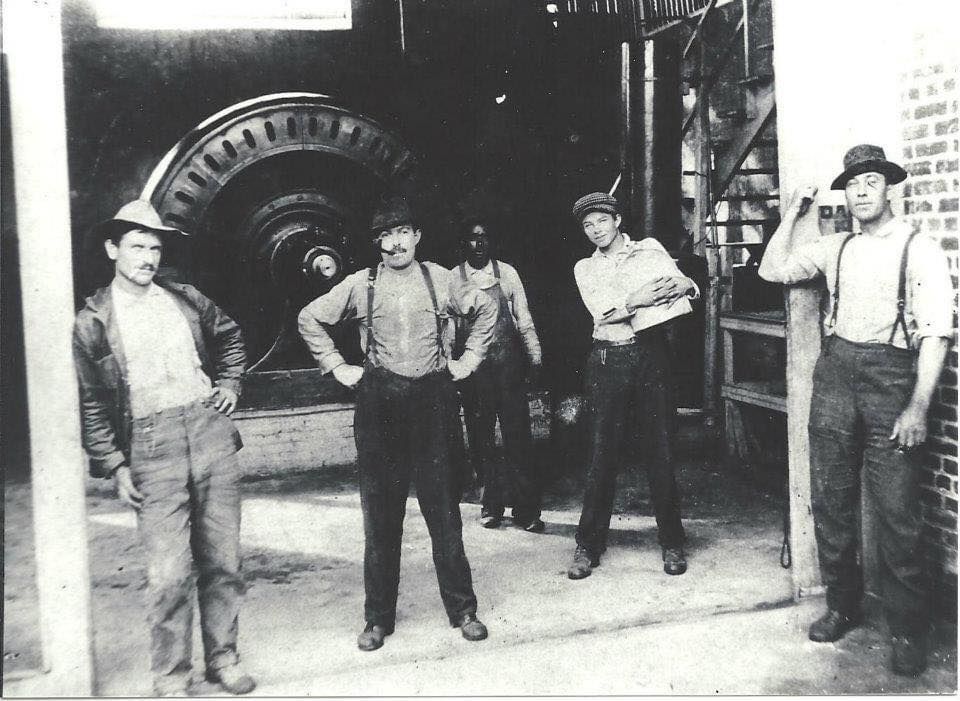
Speculations about the reach of the High Falls Plant included supplying power to the cotton mills in Forsyth, Griffin, and Jackson, as well as an “electric road” in Macon, and an “electric railway” connecting Griffin to Indian Springs. The diversion system which sent water from the base of the dam to below the natural falls, was built by the Towaliga Falls Power Company and completed in 1904. This company eventually dissolved its charter and sold the property to the Georgia Hydroelectric Company in 1925. In the end, despite loftier hopes, the crew of the High Falls Powerhouse tended the turbines which kept the lights on in High Falls and powered the cotton mills in Griffin.
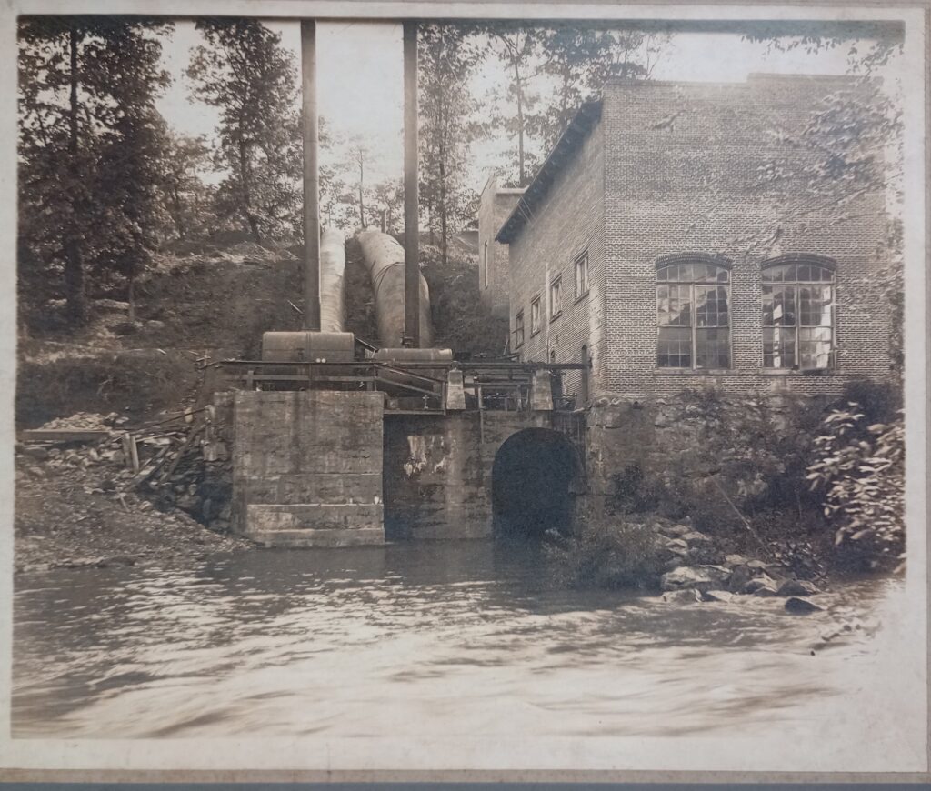
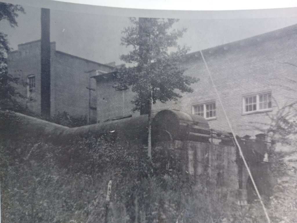
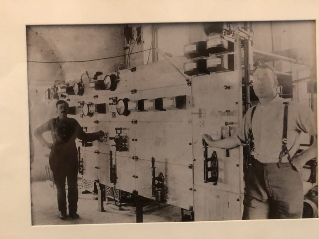
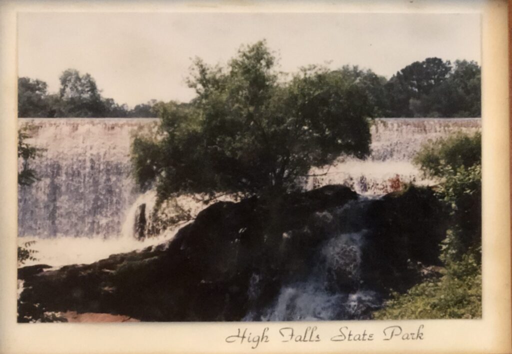
One of those crew members left his own mark on High Falls history. Crewman Golden Evans told his coworker William Walter Wynn who told his grandson Tony Wynn who told me that he dreamed about a sulfur spring on the property three times before striking out and finding it on the property of the powerplant. The exact location, however, has been lost to time. What still stands are the remains of the hydroelectric system: the dam, the earthen and rock berm wall and diversion canal, the penstock with its pipe supports, and the two brick buildings of the powerhouse. The dam, brainchild of lead engineer of the Towaliga Falls Power Company, W.C. Whitner, stands at 35 feet high, 25 feet wide at the base, 6 feet wide at the top, and 606 feet long. It impounds a nearly 650 acre lake. Georgia Power purchased all of this including the gristmill in 1930 and operated it until 1958 when industrial advancements left the fate of High Falls once again in limbo. This time a new path would begin with an unlikely source. The entire property was sold to the Hiwassee Land Company, a subsidiary of Bowaters Paper Corporation, who timbered it, auctioned off the gristmill, and donated the land to the Georgia Game and Fish Commission in July of 1961. The commission operated an “experimental park” until finally handing the property off to the State Park system which officially established High Falls State Park in 1966.
The park originally consisted of a lakeside campground and a beach for swimming. In the 1970s a second campground was constructed, a small loop trail carved into the woods, and a min-golf course installed. It is here that I must insert my own personal favorite piece of park history. In 1975 the Allman Brothers Band, the founders of Southern Rock and Roll, were living on their property in Juliette, Georgia, known as the farm. Guitarist Dicky Betts left the house one day and encountered a filming crew where he met two little known actors (at the time) Nick Nolte and Don Johnson. Hoping to show his new friends some local beauty, Betts brought them to High Falls State Park to spend the afternoon in the river. He also brought his guitar. On the banks of the Towaliga below the falls, Betts composed what would become the Allman Brothers Band’s longest studio recorded instrumental, “High Falls” which appeared on the Win, Lose, or Draw album.
By the 1980s, the beach had been replaced by an inground pool, the mini-golf course relocated, and the trail system expanded. The park became a favorite for campers, angles, hikers, swimmers, and paddlers. At some points throughout the 1980s an average of 1,000 people were visiting the park daily. Park life chugged along in a happy trajectory until the summer of 1994. Tropical Storm Alberto stalled over Central Georgia dropping an unprecedented 27 inches of rain causing rivers to breech 100 year flood plains. At High Falls State Park, the Ranger Station was flooded, the mill ruins and riverside campground were underwater, and the steel camelback was wrenched from the Old Alabama Bridge which was functioning as a footbridge at the time. The camelback and half of the bridge were washed into the raging water of the Towaliga.
Much as before, this challenge did not mean the end for High Falls. A new Ranger Station was constructed, campsites and bridge were repaired, and the park soldiered on. In 1998 Governor Zell Miller declared High Falls State Park a Heritage Preserve ensuring its significance and beauty will be protected by the Georgia Constitution for the enjoyment of future visitors. The 2000s brought yurts to the park’s lakeside campground and a Historic Trail overhaul resulting in a half mile ADA trail that offers views of all the park’s historic points of interest and the mighty falls of the Towaliga. As of 2026 High Falls State Park boasts over 100 RV/tent campsites, 9 yurts, a fully enclosed group shelter, 5 picnic shelters, almost 5 miles of hiking trails, 2 fishing docks, 2 boat ramps, and boats to rent including kayaks, canoes, and aqua-cycles. The natural, historic, and recreational resources of High Falls are accessible to more people than ever before and the world is noticing.
As the water of the Towaliga ceaselessly tumbles and chases itself forward, time, too, courses onward bringing inevitable change for our area. But High Falls, and the park that bears its name, have proven adaptable, tenacious, and industrious. Like the river, we will find a way, and it will be something for the history books.